Part 01
Photo Credit: Mark A. Wilson Department of Geology, The College of Wooster
We have all known since our school days that the holy Ganga is the national river. But many of us are still ignorant about its plight. This article portrays a detailed canvas of a crying river in context to its pollution and future threats. Finally, it contours what can be done to mitigate the effects of imminent and impending danger.
Origins
The Ganga is a perennial snow-fed river that originates as Bhagirathi from the Himalayan glacier Gangotri at Gomukh in Uttarakhand, 7010 m above mean sea level. On the other hand, another river called Alaknanda from the Alkapuri glacier joins Bhagirathi[i]. Together they make the Ganga at Devaprayag. The Ganga flows along with its many tributaries like Ghagra, Yamuna, Kosi, Gandak, Son, Ramganga, Gomti, etc., through several states like Uttarakhand, Himachal Pradesh, Haryana, Delhi, Rajasthan, Uttar Pradesh, Madhya Pradesh, Chhattisgarh, Bihar and Jharkhand to West Bengal before finally merging into the Bay of Bengal[ii].
The Ganga also flows through Bangladesh. There, people call it the Padma. In case, you do not know why the Britishers used the word “The Ganges”, here is the answer. Ganga, the Padma, and Meghna are collectively called the Ganges.
Why is the Ganga special?
The earliest record of the Ganga was found in the holy Rig Veda. Historians came to know from it that the Ganges plains were first settled by Aryans around 1200 BC[iii]. Ever since then, the Ganga has undoubtedly been the center of the social, economic, and religious aspects of the Indian lifestyle.
The Ganga is globally the thirtieth longest river and the longest in India[iv]. It has a length of 2525 km and supports the lifeline of 29 class I cities, 23 class II cities, 48 towns, and thousands of villages throughout its course[v].
The Ganga covers a basin of 861404 sq. km[vi]. In other words, it covers 26.3% of the total geographical area of our country[vii]. The Ganga basin also has the largest catchment area within the subcontinent. It covers 1.086 million sq. km of which 79% is within India[viii].
Owing to the large area of the fertile basin and catchment area, Ganga supports an enormous amount of population because of food supply and industrial ventures. Today, it sustains around 320 million people in India, Nepal, and Bangladesh together[ix]. Let me explain how exceptionally grand the situation is in the global context. Amazon has the largest river basin in the world. It is 7.5 times larger in area than that of the Ganga. But the average population density around the amazon basin is 25 people per sq. km[x] whereas, in the case of the Ganga, it is astonishingly 500 people per sq. km[x]! In short, one-tenth of the world’s population lives within the Ganga River basin. On top of it, scientists speculate that the population density will increase by over 1 billion people by 2030[xi].
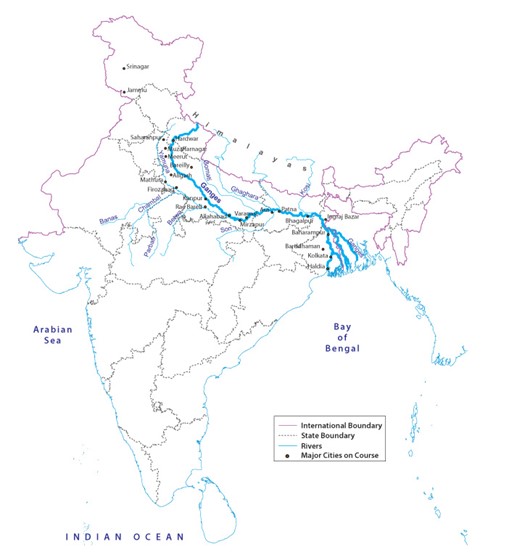
Photo credit: mapsofindia.com
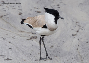
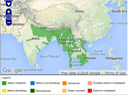
Ganga is of immense ecological importance as it supports rich biodiversity both in flora and fauna. It has over 140 species of fish and 90 species of amphibians[iii]. It provides a niche to birds like river lapwing, painted stork, etc., which cannot be found anywhere else. Furthermore, 40 species of zooplanktons, 4 crustaceans, 15 mollusks, 51 insects, 83 fishes, 12 freshwater turtles, 2 crocodiles, 48 aquatic birds, and two mammal species have been identified in the upper Ganga River stretching from Brijghat to Narora in Uttarpradesh[xii]. Ganga is also home to our beloved Hilsa fish which is exported worldwide and fetches millions of dollars.
Spiritually, the Ganga is considered holy and bathing in it is considered salvation for ages. Contrary to the Amazon basin which has a per-humid, sub-humid, and humid climate, the Ganga basin has a sub-humid to sub arid climate[x]. Because of it, the weather around the Ganga basin offers favourable conditions for the growth of hosts to many chronic diseases. Thankfully, Ganga owing to the unique bacteriophages and the high retention capacity of dissolved oxygen has self-purifying properties[xiii]. As a result, water-borne bacteria that cause dysentery and cholera get killed. Thus, the outbreak of large-scale epidemics gets prevented.
Picture credit: nmcg.nic.in
Picture credit: nmcg.nic.in
Ganga and worries
Let me quote an alarming report from the World Watch Reader: ‘The Nile, the Ganges, Amu Darya, and the Syr Darya, the Yellow River, and Colorado are each now so dammed, diverted, or over tapped that, for parts of the year, little or none of their freshwater reached the sea. Their collective diminution portends not only worsening water shortages and potential conflicts over scarce supplies but mounting the ecological damage.‘[xiv]
You can gauge how alarming the matter is. The Ganga is the fifth most polluted river in the world[xv]. The World Wildlife Fund too has declared Ganga one of the top ten rivers at risk[iii]. Being the world’s second-largest river by water discharge, Ganga River System is the major contributor to the global sediment and water discharge to the ocean. Worryingly, the annual fluxes of the dissolved metals have increased to 230–1770%, which is probably the highest among all the estuaries worldwide[xvi].
Furthermore, the scientific studies tell us that the retreat of the Gangotri Glacier has accelerated since 1780 and within 60 years from 1936, it receded by 1.147 km. Simply put, the average retreating rate is about 28 m per year[xvii]. Its impact is frightfully alarming as the scientists think it to be irreversible. Moreover, in the short term, the river flow might get enhanced but in the long term, river flow will decline due to the glaciers’ gradual disappearance.
Climate change is affecting both rainfall and runoff in the Ganga basin. Notably, in the total runoff of the Ganga basin, the share of meltwater is decreasing and the share of rainfall runoff is increasing. In the current situation, although the number of rainy days is increasing in both the upper and lower Ganga basin rainfall of more than 10 mm/day is decreasing[xvii]. This would in turn affect crop cultivation and lead to famine in certain parts of the country[xviii].
But how did the Ganga turn up this miserable?
Well, the devil lies in the data. Historically, the Ganga River basin was relatively free from anthropogenic activities until the 1940s. It converted into a disposal site for agricultural, industrial, and sewerage wastes after the independence[xix]. In modern times, sewage discharged into the Ganga River is responsible for 75% of its pollution[xx]. CPCB reports that around 12,000 million liters per day (MLD) of sewage are generated in India[xxi]. Out of which, only 4000 MLD gets treated before being discharged into the river stream[xxi]. If we zoom in further, 3000 MLD of sewage is generated from the class I and class II cities of which 1000 MLD have been treated to date[xxii]. Therefore, it is not surprising to realize that the self-purification capacity of the river alone cannot compensate for such an enormous gap between the volume of generated waste and its treatment capacity.
Furthermore, 20% of the discharge volume is from industrial wastes[xxii]. Rest is from domestic wastewater, agricultural run-offs, cattle bathing, slaughterhouse discards, dumping of flowers and oil after religious activities, burning of dead bodies, faecal matter, plastics, mass bathing, washing of clothes, throwing of construction debris, etc. [xxiii]
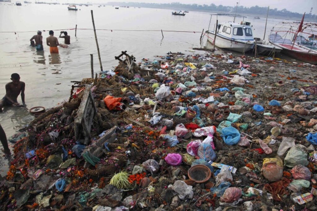
Picture credit: thehindu.com
In the part 2 of this series we will look into the possible remedies, concerns and results of the undertaken remedial policies.
Author’s Bio:

Shrestha Chowdhury is currently working as a Senior Research Fellow in the Department of Chemical Sciences at IISER KOLKATA. For her fourth and her longest blog on the TQR platform, she has attempted to pen down her thoughts on our holy and beloved river the Ganga. This project was an eye-opening journey for her both in terms of scientific temperament and spiritual context. She earnestly wants the dire state of the river to be recovered into its glorious and pristine form. Hope the readers enjoy the write-up!
References
[i] International Journal of Scientific and Research Publications, Volume 3, Issue 4, April 2013
[ii] Environment and Urbanization Asia 3(2) 343–352 © 2012 National Institute of Urban Affairs (NIUA) SAGE Publications Los Angeles, London, New Delhi, Singapore, Washington DC DOI: 10.1177/0975425312473229 http://eua.sagepub.com
[iii] Bioved, MITALI DHIMAN et al. 229 25(2): 229–242, 2014
[iv] International Journal of Prevention and Control of Industrial Pollution Vol. 6: Issue 1 www.journalspub.com
[v] Same as iii
[vi] Introduction to Our National River Ganga via cmaps; Rashmi Sanghi and Nitin Kaushal
[vii] Z.U. Shah, S. Parveen Heliyon 7 (2021) e07726 https://doi.org/10.1016/j.heliyon.2021.e07726
[viii] iScience 24, 102122, March 19, 2021 ª 2021 https://doi.org/10.1016/j.isci. 2021.102122
[ix] D. Paul / Annals of Agrarian Science 15 (2017) 278e286 http://dx.doi.org/10.1016/j.aasci.2017.04.001
[x] Poll Res. 39 (November Suppl. Issue): S266-S271 (2020)
[xi] U.N. Rai et al. / Bioresource Technology 148 (2013) 535–541 http://dx.doi.org/10.1016/j.biortech.2013.09.005
[xii] Hydrobiologia 458: 159–168, 2001
[xiii] Environ Monit Assess (2020) 192: 221 https://doi.org/10.1007/s10661-020-8152-2
[xiv] Urban Affairs (NIUA) SAGE Publications Los Angeles, London, New Delhi, Singapore, Washington DC DOI: 10.1177/0975425312473229 http://eua.sagepub.com
[xv] Environ Monit Assess (2016) 188: 444 DOI 10.1007/s10661-016-5433-x
[xvi] Mitra, S., Sarkar, S. K., Raja, P., Biswas, J. K., & Murugan, K. (2018). Dissolved trace elements in Hooghly (Ganges) River Estuary, India: Risk assessment and implications for management. Marine Pollution Bulletin, 133, 402–414. https://doi.org/10.1016/j.marpolbul.2018.05.057
[xvii] R. Singh and G.S. Singh, Integrated management of the Ganga River: An ecohydrological approach, Ecohydrology & Hydrobiology, https://doi.org/10.1016/j.ecohyd.2019.10.007
[xviii] C. Brouwer, C., Heibloem, M. Irrigation Water Management: Irrigation Water Needs. CHAPTER 2: CROP WATER NEEDS. https://www.fao.org/3/s2022e/s2022e02.htm
[xix] Sinha, M., Khan, M.A., 2001. Impact of environmental aberrations on fish- 2171 series of the Ganga (Ganges) river. Aquat Ecosyst Health Manag 4 (4), 2172 493–504. doi:10.1080/146349801317276143
[xx] International Journal of Advanced Research in Science, Engineering and Technology Vol. 2, Issue 1, January 2015
[xxi] International Journal of Oceans and Oceanography ISSN 0973-2667 Volume 10, Number 2 (2016), pp. 81-91
[xxii] Environ Monit Assess (2020) 192: 221 https://doi.org/10.1007/s10661-020-8152-2
[xxiii] Ethnology, Spring, 1994, Vol. 33, No. 2 (Spring, 1994), pp. 127-145